Saint-Louis — Étape 1 Complete
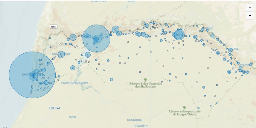
The Saint-Louis campaign was launched during the COVID-19 pandemic through the WHO-UNICEF GIS Working Group for COVAX. A team of 12 local OpenStreetMap community members validated health facilities across the medical district over three months, producing one of the most complete open health facility datasets in West Africa. The validated data remains freely available on OpenStreetMap today.
The campaign followed the five-phase healthsites.io methodology. Saint-Louis is the first district to reach Étape 2 — the evidence and policy engagement stage.
The User Story That Drove the Work
"As a pregnant mother I want to know where the nearest emergency health service is so that I can plan for potential complications during childbirth."
This user story — developed with local communities through Human-Centred Design workshops — shaped every aspect of the field validation. From 397 facilities visited, 35 were identified as likely to support emergency pregnancy referrals, based on facility type, bed availability, emergency health status, and contact information.
Étape 1 Results
- 398 health facilities validated and uploaded to OpenStreetMap
- 1,325 beds documented across the district
- 315 facilities confirmed with access to power
- 35 facilities identified as likely to support emergency pregnancy referrals
- 16 personas and 101 user stories co-developed with local communities
- 12 OSM community members trained as field validators
- Data shared directly with national health authorities, COUS, and PATH
- Open-source R toolset developed for naming convention reconciliation
Étape 2 — Evidence and Policy Engagement
Étape 1 produced the data. Étape 2 puts it to work.
Component A — Confirming the 35 facilities The 35 emergency facilities were identified based on data attributes. Étape 2 physically confirms whether they are genuinely suitable for emergency pregnancy referrals — through clinical assessment, not data proxies alone. The result will be an actionable, clinically verified dataset directly useful to health planners and emergency responders.
Component B — NSO–MoH–OSM Interoperability A formal data governance framework will be established between the National Statistics Office, the Ministry of Health, and OpenStreetMap — bridging three registries that currently operate independently. This framework will be documented and replicable for future campaigns.
Component C — Ministry of Finance Advocacy Validated health facility data is not a project cost. It is permanent national infrastructure, maintained by the OpenStreetMap community and freely available indefinitely. Étape 2 supports the Ministry of Health in making this argument to the Ministry of Finance — an evidence-based case grounded in the PNDSS 2019–2028 financing axis and SDG 3.8.1 monitoring requirements.
Who We Are Looking For
We are inviting support from organisations and individuals who share a commitment to improving health outcomes for women in rural Africa. This includes:
- Health practitioners and clinicians with expertise in maternal and emergency care in sub-Saharan Africa
- Donors and foundations focused on women's health, maternal mortality, or universal health coverage
- Pharmaceutical companies and health insurance organisations operating in West Africa
- UN agencies including WHO, UNICEF, and UNFPA
- NGOs and civil society organisations working on health data, maternal health, or community health systems
- Researchers and academics working on health economics, health geography, open data, or health systems strengthening — including through LAPES at Cheikh Anta Diop University and the MoHSA Health Economics Unit
Contact us to discuss how you can support Étape 2.
Partners
Étape 1 was delivered in partnership with OpenStreetMap Senegal, the Senegalese Ministry of Health and Social Action, WHO, UNICEF, and the Global Fund COVID-19 Response Mechanism.